Eye resident Dale McKean has asked me to share his objections to this development with residents. I’ve covered this story previously on numerous occasions and as I’ve previously said, this isn’t just another building application, its probably the largest single housing development that has ever been put through the planning process for the village. Please remember, once Larkfleet have finished building the last house it won’t be them that have to deal with the consequences of such a large site, it will be everyone who lives here.
The area in question was approved with the Peterborough Local Plan in July 2019. The previous local plan was supposed to cover the time period to 2025 but lasted just a few years until the government ‘changed the goal posts’ so to speak.
Notes
- The Peterborough Local Plan contains what Peterborough City Council thinks is the most appropriate planning policies for the growth and regeneration of Peterborough and the surrounding villages up to 2036.
- LP40 is a policy in the Peterborough Local Plan. It was included due to what the council says is the ‘complex makeup’ of the site. In other words its due to the large number of houses and the fact that the entrance is sited close to the primary school on what can be at times a busy road.
Objections – 19/00836/OUT Eyebury Rd Eye
The deadline for sending objections is Thursday 26 September 2019 and you need to provide your name and address. Objections can be emailed to planningcontrol@peterborough.gov.uk or an online objections can be made at https://planpa.peterborough.gov.uk/online-applications/applicationDetails.do?activeTab=makeComment&keyVal=PSERGMMLG3U00
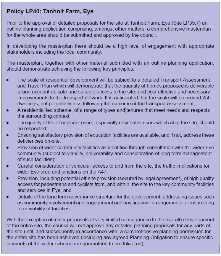
Policy LP40: Tanholt Farm, Eye states:
Prior to the approval of detailed proposals for the site at Tanholt Farm, Eye (Site LP39.7) an outline planning application comprising, amongst other matters, a comprehensive masterplan for the whole area should be submitted and approved by the council. In developing the masterplan there should be a high level of engagement with appropriate stakeholders including the local community.
The masterplan, together with other material submitted with an outline planning application, should demonstrate achieving the following key principles:
There are eight key principles and the objections below are grouped into them
1. I object because this application does not meet the condition of LP40 (pasted below)
“The scale of residential development will be subject to a detailed Transport Assessment and Travel Plan which will demonstrate that the quantity of homes proposed is deliverable taking account of; safe and suitable access to the site; and cost effective and necessary improvements to the transport network. It is anticipated that the scale will be around 250 dwellings, but potentially less following the outcome of the transport assessment”
Objections are:-
- In the last 5 developments by this developer there has been inadequate parking facilities and reduced road width which means many cars are parking on pavements and residents with pushchairs and mobility scooters and those with sight problems have to go into the road to pass. I object to this application as there is inadequate parking facilities due to over development of the site.
- The traffic report that was commissioned claims that “there is nothing to suggest that the introduction of the proposed development….would prejudice the safe operation of the local highway network.” The traffic visit was undertaken in July 2 weeks before school holidays, when many more parents are willing to walk to school, is not representative of the situation. Especially in the winter months when the number of vehicles used to drop off children increases significantly. A new report should be undertaken in the winter months during school term
- I object to the entrance to the site shown as a T Junction, this needs to be traffic lights as due to the rat run down Eyebury Rd residents will not be able to get out of the site in the morning rush hour also this will be the same for anyone dropping of their children to the school drop of area leading to residents causing parking Issues on Eyebury Rd / Little Close rather then get stuck in the new estate trying to get out
- The proposed development by Larkfleet Homes would potentially have entry from Eyebury Road which already has severe traffic issues. The Primary School and a Residential Home are situated on this road. The road itself, as it exits the village towards Oxney Road, is not a fully two way road and has a section where vehicles have to use passing places. In the early morning traffic is continually backed up to the roundabout at the junction with the High Street and Thorney Road. This is essentially work and school traffic. The reverse happens at the end of the school/working day
- There is nothing in the planning proposal to slow the traffic down. Moving the chicane that is near Field house further South will bring it much closer to the blind corner at the Southern end of the proposed development and I’m concerned that without alterations to the road to reduce the speed of traffic
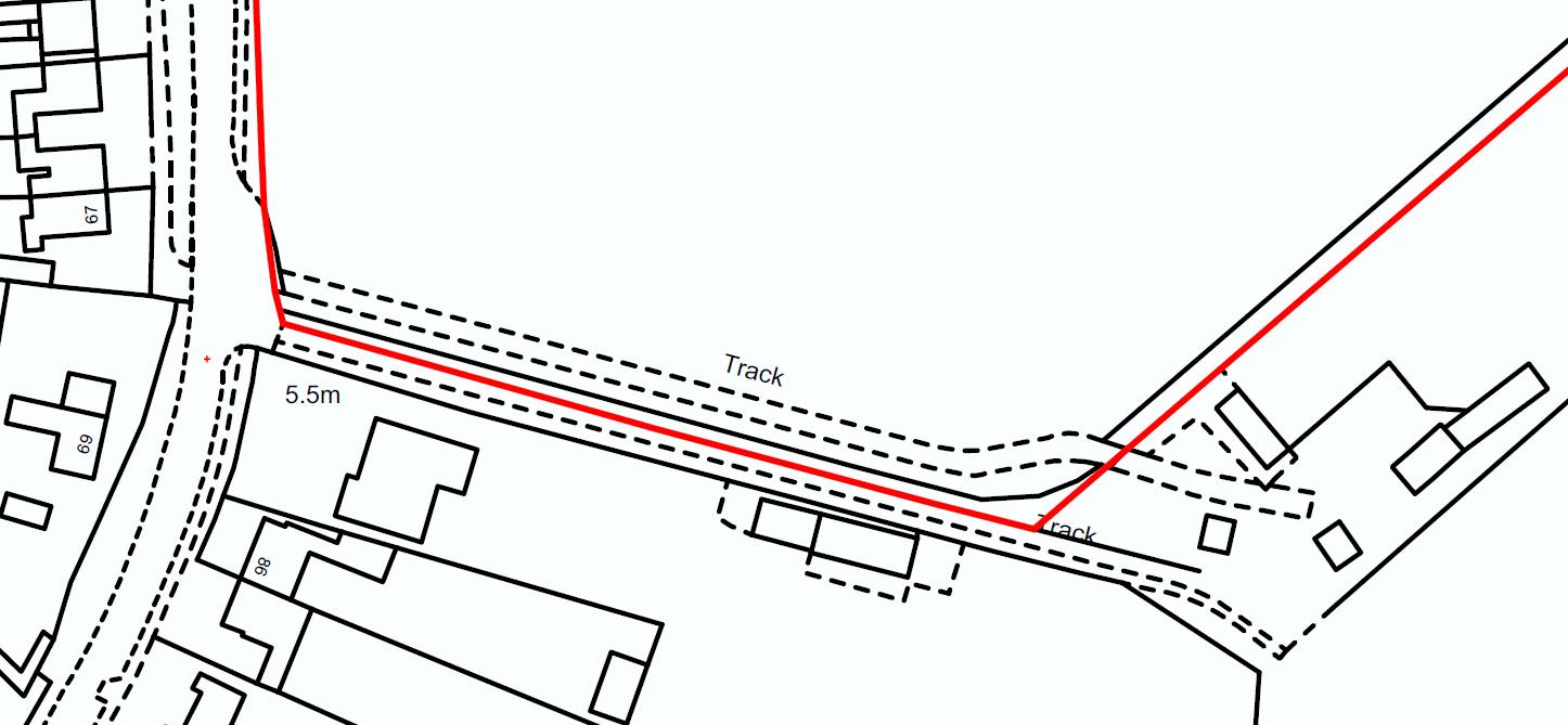
- Heavy trucks are banned from the use of Eyebury Road, so construction traffic will have to use the Southern Oxney Road way into Eye, this partial single track route is already heavily used by Biffa Lorries deliveries to the land fill site and at times difficult to use, the risk of incidents here also has to be taken into consideration.
- Already site access traffic have been using Eyebury Rd access through the village which has a weight restriction added many years ago because heavy traffic was damaging the water supply and drainage systems leading to leaks, I cannot find a Highways and Anglian Water assessment of the impact on this road and the utilities if it will be used by Larkfleet for heavy lorries delivering to the site for the 2 to 3 years of building the homes and roadways
- The traffic situation on Eyebury road is difficult, particularly around the church and the school during peak times there. Travelling north towards the church is hazardous due to all the cars parked and the chicanes. The bend in the road around the church involves a degree of risk as it is not possible to see the oncoming traffic until you have committed to the turn and you are in the path of that traffic.
- The plan to have the entrance to this new development on Eyebury Road would exacerbate existing problems on that road at peak times. The traffic assessment that has been done does not reflect the actuality of the village today: it was carried out before the developments on Thorney Road were finished, and does not take into account the additional traffic that the 100 new houses currently being built along Crowland Rd
- There needs to be traffic calming measures added to Eyebury Rd due to the extra vehicles the site will create including raised works at the level crossing and bollard zones, level with the paving to ensure motorists are forced to slow down. And Toucan crossing at school and traffic lights at the junction from the site onto Eyebury Rd and safety measures introduced on the corner of the Church
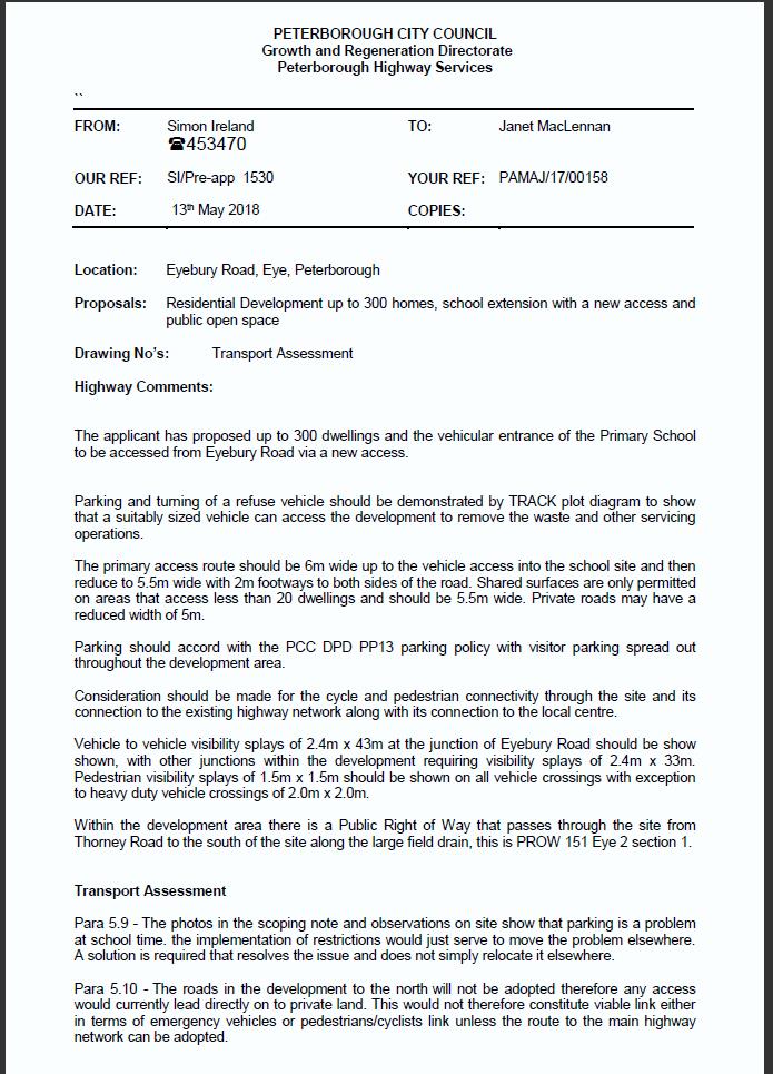
- Larkfleet have provided BWB Transport Assessment (NTT2566) date 31/5/19. In section 1.9 pasted below it states:Initial pre-application traffic comments dated 12 February 2018 were provided by PCC, following a meeting with Larkfleet Homes. Following on from this further pre-application comments were provided by PCC dated 13 May 2018.It was suggested by PCC that:
-
- The existing public right of way through the middle of site is upgraded to a footway/cycleway to provide connectivity to Thorney Road, although it is noted by PCC that this currently appears to be unachievable as an adopted route to the north cannot be provided.
- It also needs to consider whether some of the development can be accessed from Phase 6 of the existing Larkfleet Homes development along with the scope for other footpath/cycleway improvements, although it is then noted by PCC that as the roads in the Phase 6 development will not be adopted that this would not be a viable link either in terms of emergency vehicles or pedestrians / cyclists unless the route to the main highway can be adopted.
This would mean the approaches mentioned in the design and access statement would not viable e.g. using public footpath for cycle way and pedestrian access also request from landscapes to light the Right of Way footpath and using the Thorney Rd site for pedestrians/cycle and emergency access
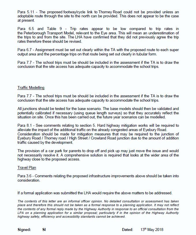
PCC Highways have raised a number of Issues during pre application stage (pasted below) including amongst other things inaccuracies in trip rates and traffic modelling and not including school traffic to and from Eyebury Rd area, have these Issue been rectified in the documents provided in this application ?
2. I object because this application does not meet the condition of LP40 (pasted below)
“A residential led scheme, of a range of types and tenures that meet needs and respects the surrounding context”
Objections are:-
- The housing types should be mainly 3 to 5 bedrooms to respect the context of the houses surrounding the site
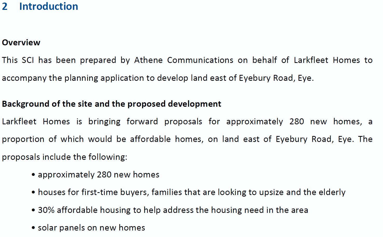
- There is no provision in the application for the elderly as stated by Larkfleet in the Statement of Community Involvement Apr 2019 Eyebury Rd Planning Ref 1900836OUT section 2 Introduction (pasted below)
- In Eye Village there is a shortage of Bungalows, given the changes in the demographic profile this shortage will increase so the site should have some within it
- Due to the growing elderly population in Eye there is a need for an additional supported living facility such as the 52 Room Spinney in Eye, it should be located next to Field House for ease of access for its residents to Eyebury Rd, this should only be 2 stories high and should have adequate parking for its residents and visitors, The Spinney was built with not enough parking leading to parking Issues for local residents. So this site should provide enough
- More provision of bungalows and a supported living scheme for the elderly will help with the pressures on the school, doctors, children and youth provision due to the number of reduced residents and them being in the later stages of their life, the other advantage will be those moving into such accommodation will then release housing suitable for families
- The housing types on this site should be mainly 3 to 5 bedrooms as there is a need for family accommodation in the village
- I am unable to find information of the solar Panels being included on each house as stated by Larkfleet in the Statement of Community Involvement Apr 2019 Eyebury Rd Planning Ref 1900836OUT section 2 Introduction (pasted below)
3. I object because this application does not meet the condition of LP40 (pasted below)
“The quality of life of adjacent users, especially residential users which abut the site, should be respected”
Objections are:-
- Field House a residential Care / Nursing Home for the elderly and vulnerable residents many of which have dementia will have a number of houses in close proximity and a new access road to the site. I cannot find any noise reduction approaches to protect these residents from noise and dust pollution including reduced working times e.g. no evenings , night times, early morning or weekend working
- For the houses to be built in close proximity to Eye Primary School and a new access road and drop off area to the site. I cannot find any noise reduction approaches to protect the children from noise and dust pollution including reduced working times during assembly times and exam sessions
- A construction management plan is required before any work is started
- HGV Site construction and delivery vehicles need to use the route that landfill site lorries use at present that is Parnwell Way, Oxney Rd, Eyebury Rd entering Eye Village from the south being the closest point to the site entrance
- Light goods site construction delivery vehicles need to use the A47 rather than come through Eye Village Peterborough Rd/High St or through Eye Green Crowland Rd, Thorney Rd, they will need to be reduced size and weight due to the village weight restrictions and limited width along Eyebury Rd.
- On site parking will be needed from day 1 for site staff as there is no room on Eyebury Rd and surrounding roads for parking
- Wheel wash facilities and frequent road sweepers will be needed from day one
- An air quality assessment of the impacts of a development in the local area is required especially the impact on the School children and the residents of Field House and Eyebury Rd. In 2017 The Chief Medical Officer “identified pollution as a major threat to public health presenting health challenges in areas including cardiovascular disease, cancer, asthma, and chronic obstructive pulmonary disease.” We do not want an increased risk to our health in the village, particularly not for our children
- As mentioned in the Tree Officers report dated 10th Sep 19 ‘There needs to be significant tree/shrub planting within the proposed school extension area especially to the boundaries with the adjacent new housing, and along/adjacent to; the central northern boundary and up the boundary heading NE towards Thorney’
- No mention of how the Public Right of Way footpath running through the site will be kept open during the years of building these houses
4. I object because this application does not meet the condition of LP40 (pasted below)
“Details of the long term governance structure for the development, addressing issues such as community involvement and engagement and any financial arrangements to ensure long term viability of facilities.”
Larkfleet statement in the planning design and access statement dated Apr 19 does not include any time frames, open space and equipment designs and any financial arrangements to ensure long term viability of facilities. (Pasted below)
‘The open space provided by the development along with elements of the SUDS will handed over to a management company owned by the residents of the scheme. This will be initially set up and controlled by Larkfleet Homes but will be handed over to residents following the completion of the open space and residents being satisfied with it.’
5. I object because this application does not meet the condition of LP40 (pasted below)
“Ensuring satisfactory provision of education facilities are available, and if not, address these deficiencies on-site;”
Objections are:-
- The School is already full and has a waiting list and there is no plan and timescales to show how its class rooms, kitchens, dinning, assembly, sports, other support areas and playing fields will be expanded.
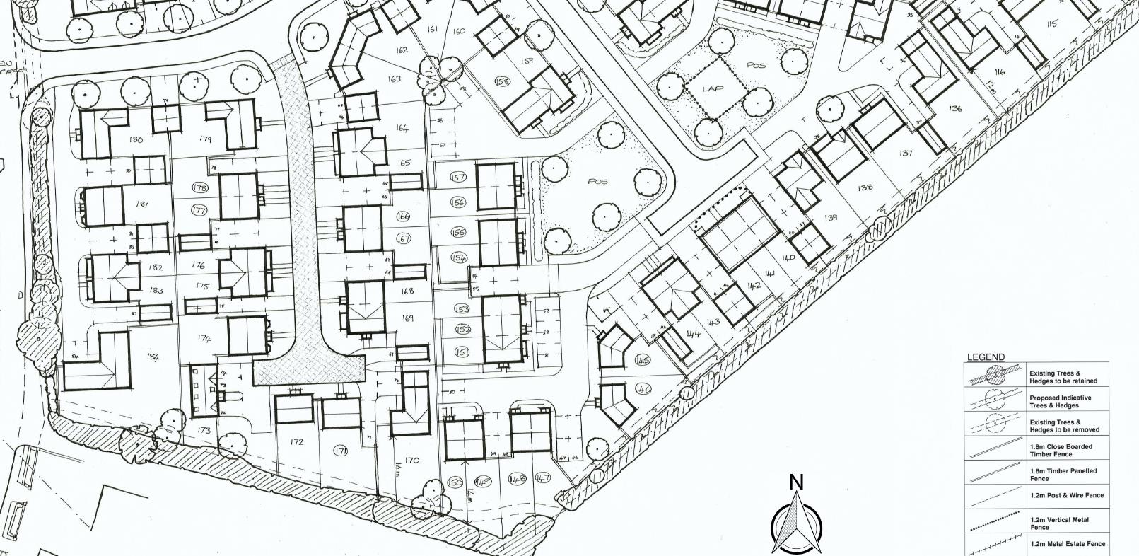
- The land allocated for the school development is inadequate because the school will need to increase its footprint by 50% to cope with a new form entry along with increases in playground, playing fields and the new vehicle drop of point for the safety of the school children as a consequence of the increased road traffic, as the site encloses the school completely there will be no opportunity for it to expand in the future so this land allocation needs to be increased as part of this application.
- The master plan proposes a school pedestrian/cycle access from the Larkfleet development onto the school site. This proposal would mean the access goes directly across the planned sports pitches. This of course would be impractical to have a path through a sports field, the path will need to be around the perimeter of the sports field, which will mean more land needs allocating to the school for this.
- PCC Education Officers has identified in the response dated 28/8/19 that the land allocated for the sports pitch is too small, which will mean more land needs allocating to the school for this.
- PCC Education Officers suggests the school pedestrian/cycle access should be through Fountains Place. This would be impractical as the developers do not own or have right of way through Fountains Place, it would be opposed by those residents due to the impact of the pedestrian cycle traffic on the area and residents as well as cars parking in Fountains Place with parents then walking their children’s through to the school
- The drain needs to have a crossing point for pedestrian and cyclist at its northern point
- Below is a summary of the current situation at Eye Primary School as provided by the Area Education Officer to our ward Councillor by email on the 12th Sep 19. The data confirms that the school is full and has a waiting list in every year with the exception of year 4 and year 6. Already Reception has had 10 extra places allocated above the PAN of 60
- Below is a summary of the current waiting list (Total of 29 – Plus 10 above PAN already in Reception) and this is before the approx. 100 houses currently being built on Crowland Road, The school is forecast to be admitting over and above its capacity of 60 in future years.
| Reception | Yr 1 | Yr 2 | Yr 3 | Yr 4 | Yr 5 | Yr 6 | Total | |
| In Cachment | 1 | 4 | 2 | 2 | 1 space available | 2 | 1 space available | 11 |
| Outside Cachment | 12 | 4 | 0 | 2 | 0 | 0 | 0 | 18 |
| Total on waiting list | 13 | 8 | 2 | 4 | 0 | 2 | 0 | 29 |
i. Base on the Education Officers response to the application in j) below and LP40 policy for the developer ensuring satisfactory provision of education facilities are available, and if not, address these deficiencies on-site;
The Developer will need to provide on site the following which is currently not in the submission:
-
- Quantity 96 Early Years Provision
- Quantity 43 Primary School (by Yr 21/22)
As there is no secondary school in the village the Developer will need to provide an off site contribution for the additional 75 Secondary aged children, the cost identified in the Education Officers response will be £1,666,650 which is currently not in the submission:
j. The education officers response to this application dated 28th Aug 19 states (based on 300 houses)
2.1 The development of 300 houses is forecast to generate
-
- 90 0-3 year olds
- 120 Primary aged children
- 75 Secondary aged children.
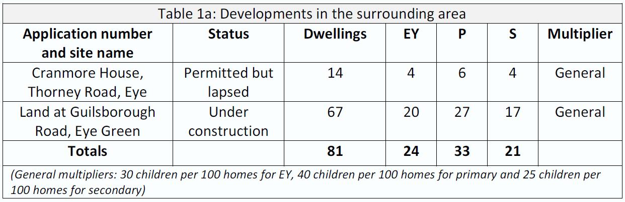
3.1 There are a number of other developments proposed in the area and the cumulative impact of these also needs to be considered. These are listed in tables 1a and 1b.
4.1 Early Years Provision
There is currently one pre-school, one day nursery and several childminders in Eye village as shown in table 2. There is full day care setting due to open in January 2020, the approximate capacity of 60 places also needs to be considered.
Table 3 shows the number of 15 and 30 hour Early Years places required in Eye if all of the developments proceed.
The forecast demand exceeds the current capacity in the village. Therefore it is necessary to seek contributions to mitigate the effects from this development.
4.2 Primary Provision
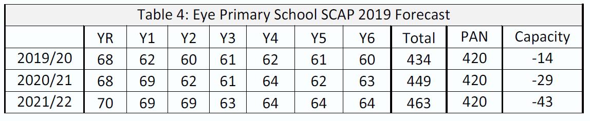
Eye Primary School is the catchment primary school for the village. Table 4 shows that there is currently a deficit of capacity at Eye Primary School.
There are forecast to be 120 primary aged children generated by this development. There are also a number of other developments coming forward in the village. The approved developments will generate an additional 27 primary school children (see table 1a). Local plan allocations and lapsed applications (see table 1a and 1b) could generate an additional 13 primary aged children. There is not currently capacity at Eye Primary for these children. So, it is recommended that contributions are sought in order to mitigate the effects of the development.
4.3 Secondary Provision
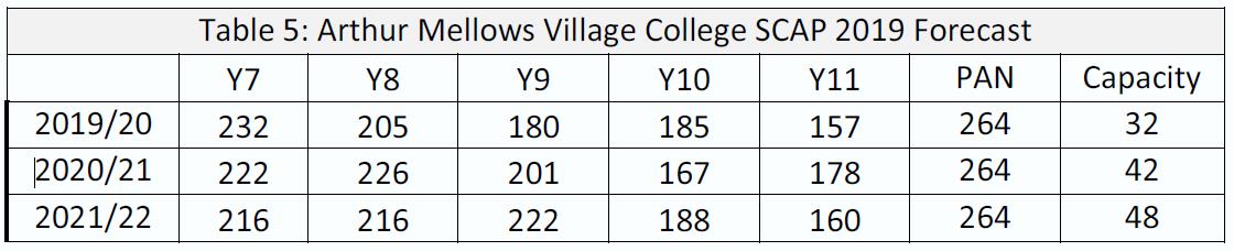
Arthur Mellows Village College is the catchment secondary school for the village. Table 5 shows the school’s forecast capacity over the next three years.
There are forecast to be 74 secondary aged children generated by this development. There are also a number of other developments coming forward in the village. The approved developments will generate an additional 17 secondary school children (see table 1a). Local plan allocations and lapsed applications (see table 1a and 1b) could generate an additional 8 secondary aged children. There is not currently capacity at Arthur Mellows for these children. So, it is recommended that contributions are sought in order to mitigate the effects of the development.
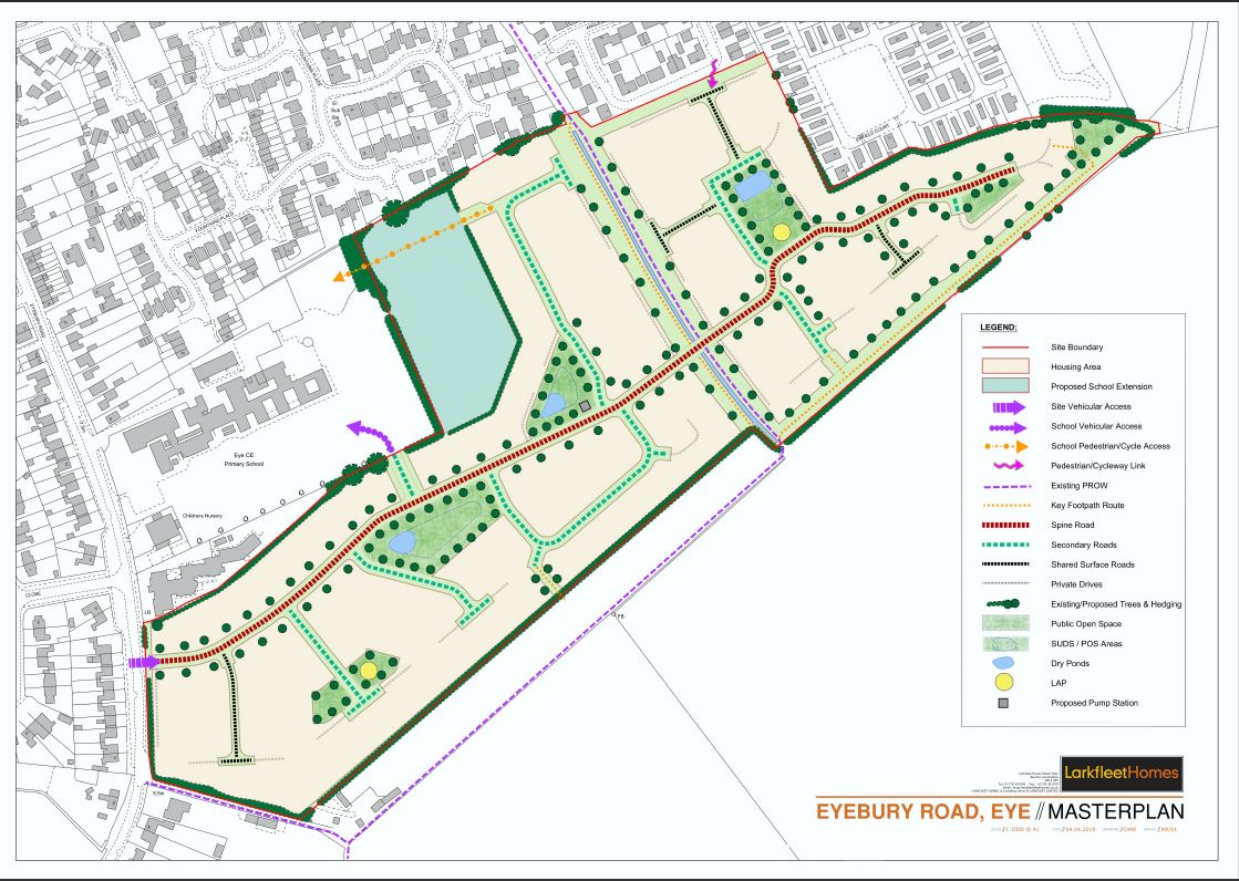
5.0 Response to proposed site Masterplan
The masterplan designates a piece of land for the proposed school extension. The Council commissioned a RIBA Site Capacity Study to explore options for this extension. The current designation of land is not of sufficient size to fit sports pitches which meet Sport England guidelines, the diagram below shows the pitch overlapping the current boundary. The Council proposes that the site boundary is adjusted and made rectangular in order to accommodate the pitches.
6.0 Projects
6.1 Early Years
There is currently no planned expansion project for Early Years provision in Eye. Officers would need to explore potential projects in order to establish costs.
6.2 Primary
A potential project to expand the school by 210 places (1 form of entry). This will require a financial contribution in addition to the land the developer is offering. The cost of this is currently unknown.
The boundary for this land will also need to be changed in order to fit the required sports pitches.
6.3 Secondary
Manor Drive Secondary Academy is a new planned 6FE school to be built on the Paston Reserve development. It is due to open in September 2022. The school at Paston Reserve will cater for 6FE at the cost of £20m. The cost per pupil is £22,222. The cost to provide 75 secondary places at £22,222 per place is £1,666,650.
6. I object because this application does not meet the condition of LP40 (pasted below)
“Provision, including potential off-site provision (secured by legal agreement), of high quality access for pedestrians and cyclists from, and within, the site to the key community facilities and services in Eye;”
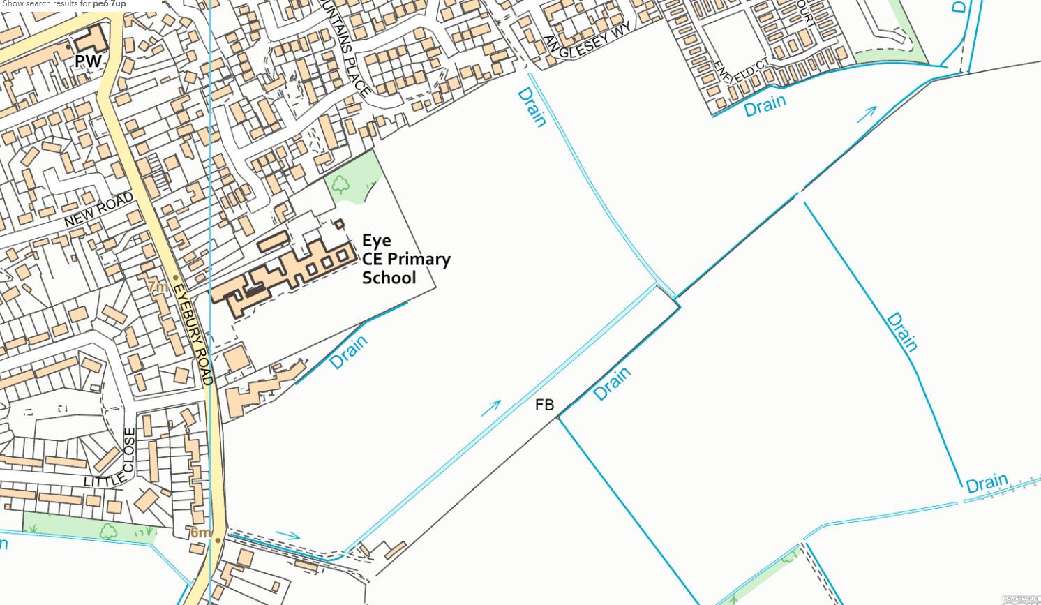
- There is no mention of increasing the footpath width along Eyebury Rd to cope with those residents on the new site walking to the schools Eyebury Rd entrance or into the Village of Eye and its facilities
- I cannot find any mention of safety measures as the gradient and depth of the drain running through the site will be a danger to the public and children
- I cannot find any mention of how the edge of the drain which is a Public Right of Way footpath is to be maintained and available for Public use not just the residents of the site
- I cannot find any mention of cycle ways within the site and along Eyebury Rd to the Village
7. I object because this application does not meet the condition of LP40 (pasted below)
“Provision of wider community facilities as identified through consultation with the wider Eye community (subject to viability, deliverability and consideration of long term management of such facilities)”
- The Doctors in Eye is at capacity and there is no plan and timescales to show how the surgery and parking will be expanded to accommodate the new residents
- I disagree with Larkfleets statement (pasted below) from there Planning and design and access statement dated Apr 19 Page 25. As the school is not open to the public for safety reasons and any use of its facilities needs to be supervised by a member of staff
In addition, the land provided for the school expansion can also be utilised by the wider community if needed, in much the same manner as the school currently allows the use of the playing of fields in the summer holidays for activities such as football.
8. I object because this application does not meet the final condition of LP40 and should be rejected and no work should be started until it does given the site is made up of 2 parcels of land the Policy below in LP40 needs to be strictly adhered too
“With the exception of minor proposals of very limited consequence to the overall redevelopment of the entire site, the council will not approve any detailed planning proposals for any parts of the site until, and subsequently in accordance with, a comprehensive planning permission for the entire site has been achieved (including any agreed Planning Obligation to ensure specific elements of the wider scheme are guaranteed to be delivered).”
9. I object to 300 houses which is an over development of the site and will lead to more traffic Issues and pressure on the School , Doctors and Infrastructure, the adopted Local Plan and the Inspectors report is for 250 houses, possibly less after the traffic assessment not 300
The Inspectors Report on the Examination of the Peterborough Local Plan (File Ref PINS/J0405/429/9) states
Large Village Allocations – Policy LP39 & LP40
- The Plan allocates 9 different sites within large villages. All but one of the sites will yield less than 100 dwellings each, with many yielding far lower numbers. The largest site is expected to deliver around 250 homes and this site is in Eye. The development of this site will be more complex and so has its own policy (LP40).
10. I object because this application as no Geophysical survey or trench trialling has been undertaken
- Archaeology Services Officer (Dr R Casa-Hatton) have written to planning 28/8/19 for this application as follows:
Given the archaeological potential of the site, as indicated by the desk-based assessment submitted with this application, a programme of work should be carried out predetermination It should include a geophysical survey possibly followed by an evaluation by trial trenching to be informed by the results of the geophysical survey
The propose development is located within an area of archaeological interest. Besides the reported early prehistoric stray lithics associated with the gravel drifts and later metalwork, former and recent investigations in advance of gravel extraction have uncovered evidence for Bronze Age and Romano-British settlements and field systems to the south, as well as Anglo-Saxon burials to the north of the subject site.
11. I object to this application as the Larkfleet Location Map Ref L—/LP/01 shows the site boundary incorrectly, it includes a private track to a stables and paddock beyond and another public footpath and track adjacent to that on its southern boundary opposite 67 Eyebury Rd
I object to this application as the Larkfleet Location Map Ref L—/LP/01 and Larkfleet sketch layout sheet 1 of 3 shows housing being built on top of a number of drains and a private track to a stables and paddock beyond on its southern boundary opposite 67 Eyebury Rd see PCC Hawkeye map below
12. I object to this application as there is not enough Open Space and Children’s play areas due to over development of the site.
There is a shortage of Open Space and Children’s Play areas already in Eye due to reduced or no facilities being provided by Larkfleet in the previous 4 large developments they have built in Eye.
The Planning Wildlife Officer Mr J D Fisher in his report 27/8/19 also raises concerns of lack of Open Space. Pasted below:
‘It is noted that the application site is allocated in the Local Plan for up to 250 dwellings, however the applicant is attempting to squeeze an additional 50 dwellings into the site which is of concern, particularly given the apparent lack of on-site open space provision, including natural green space. It is important that the necessary amount of open space as required by LP21 is provided on site.’
The Officer also raises the lack of Open Space again in the Designated Sites section of his report, pasted below:
The Ecology Report identifies Eye Green Local Nature Reserve/ County Wildlife Site as being located 270m north of the application site. This development proposal is likely to result in significant increases in visitor numbers to the LNR with associated visitor pressure such as increased levels of littering, dog fouling, vandalism and anti-social behaviour, which will create a greater financial burden on the Council as the site’s owners, particularly given the lack of green-space provision currently proposed within the development itself.
13. I object to this application as the Larkfleet flood ponds utilise the Open Space area allocations rendering them unusable during heavy rain events and winter
14. I object to this application as the Larkfleet plan shows the sloping area to the Water drain / Dyke running through the site as Public Open Space
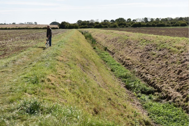
- Clearly this cannot be used due to the deep drain and gradient of the sloping sides
- The sides are needed for North Level Drainage machinery access when cleaning the drain
- The gradient and depth of the drain will be a danger to the public and children
- The edge of the drain is a Public Right of Way and will need to be maintained and available for Public use not just the residents of the site
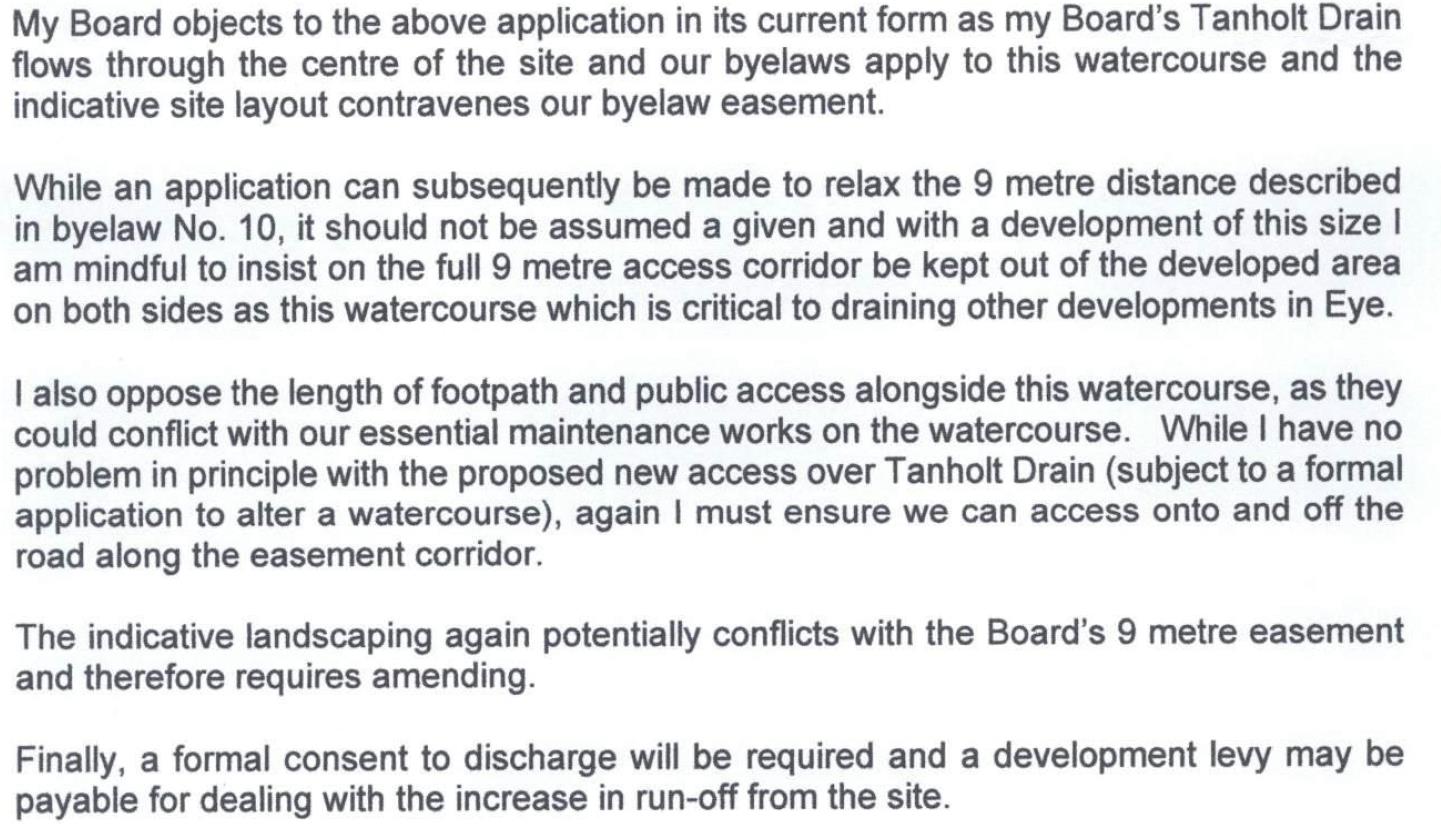
15. I object to this application as per the items raised below by North Level District Internal Drainage Board response dated 22nd Aug 19 pasted below
16. I object to this applications Open Space and Playing area as it is inadequate, the area needs to be a single area for residents to use and of an overall size of 2.149 Ha (based on 283 houses) – see my detailed calculations and policies below to support my objection
Adopted Local Plan Policy LP 21 states
Where the facilities are created on-site as part of a development, they should:
- be of an appropriate size and quality in accordance with the standards in Appendix D;
- be designed to be safe and accessible to all potential users;
- maximise green infrastructure benefits and functions;
- take opportunities to connect to the strategic Green Infrastructure Network;
- have a clear funding strategy and appropriate mechanisms secured which will ensure satisfactory long term maintenance and management of the facility.
Appendix D of Local Plan defines Provision for Open Space, Sport and Recreation Standards
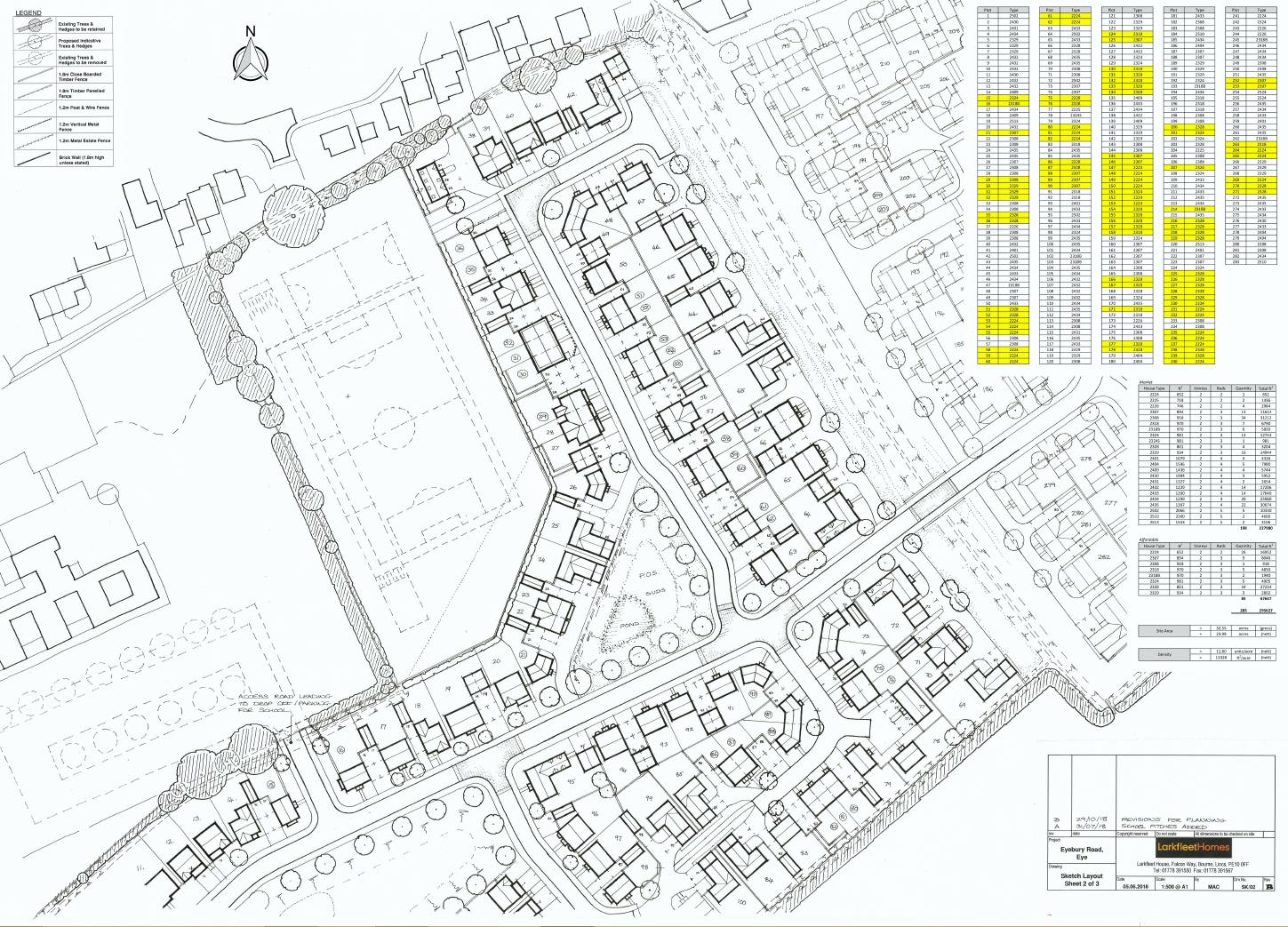
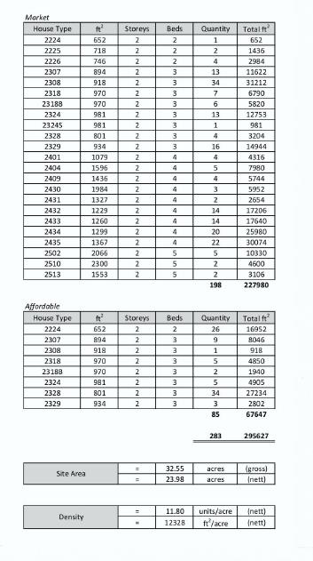
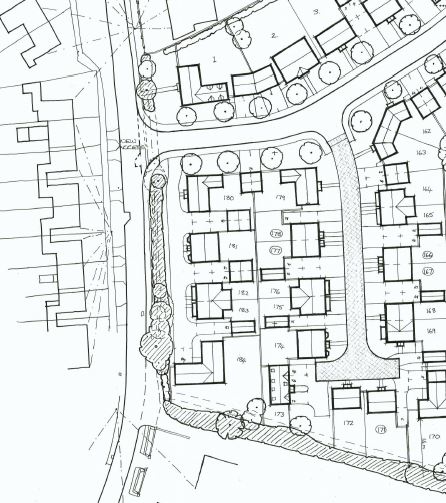
This application is for 300 houses however the Sketch Layout Sheets 1 to 3 Rev A/B dated 29/10/18 are for 283 houses in this objection 283 houses and the types shown in the drawing (table pasted below) has been used to calculate the population of the site for use in calculating the Open Space needed as per App 4 of the Local Plan.
Adopted Local Plan Policy LP 21 states Part C: Converting Standards per Person
In order to convert the standard per person into standards per dwelling (and subsequently, standard per development scheme), the following formulas apply:
- 1 bed dwellings = assumes 1.2 people average occupancy
- 2 bed dwellings = assumes 1.9 people average occupancy
- 3 bed dwellings = assumes 2.9 people average occupancy
- 4+ bed dwellings = assumes 3.1 people average occupancy
Check the amount needed based on the 283 houses listed below
- 2 Beds 33 x 1.9 = 62.7
- 3 Beds 153 x 2.9 = 443.7
- 4 Beds 88 x 3.1 = 272.8
- 5 Beds 9 x 3.1 = 27.9
Based on the Policies and Larkfleets information the Total people for calculations will be 807
Part A: Open Space Standards And Part B: Playing Pitch Standards are pasted below
| Open Space Type | Quantity
Standard |
Accessibility
Standard |
Quality Standard | Area based on 283 Houses & types defined population of 803 |
| Neighbourhood Parks | 1.36ha per
1,000 population |
560m straight line
distance |
All spaces should meet Green Flag standard wherever possible |
1.092 Ha |
| Children’s Play | 0.04ha per 1,000 population –
equipped/ designated play areas (LAP, LEAP and NEAP) |
LAP – 200m straight line distance (where possible) LEAP – 450m straight line distance
NEAP – 800m straight line distance |
Children’s play
provision should provide a range of facilities associated with the type of facility |
0.03Ha |
| Natural Greenspace | 0.42ha of
Accessible natural greenspace per 1,000 population (which ideally meets the criteria for LNR designation |
300m to natural greenspace of at least 2ha (although a minimum of 0.25ha appropriate within existing urban areas) 2km to natural greenspace of at least 20ha 5km to natural greenspace of at least 100ha 10km to natural greenspace of at least 500ha | Areas of natural and semi-natural greenspace should be of adequate quality and support local biodiversity |
0.337 Ha |
| Allotments | 0.29ha per
1,000 population |
560m straight line
distance |
Allotment sites
should be of and support the needs of the local community. Allotment sites which under perform in terms of their value to the local community should be improved |
0.232 Ha |
| Playing pitches | 0.86 pitches per 1,000 population | As a guide, the expected quantity standard for playing pitches is 0.86 pitches per 1,000 population |
0.69 Ha |
So based on the Policies and Larkfleets information the calculated Total Open Space and Playing area is
- Total for Green Space and Play Area is 1.459 Ha
- Total for Playing pitches is 0.69 Ha
- Overall Total Open Space and Playing area is 2.149 Ha
- The above will need to be in addition to the land allocated for school use which will be securely fenced off
17. I object to this application as there is inadequate provision of Open Space and over development of the site as described below
- PCC Policy LP21 – New Open Space, Outdoor Sport and Recreation Facilities. Part A New Open Space, Outdoor Sport and Recreation Facilities states
- ‘The council’s first preference is for on-site provision in a suitable location’
- An off-site provision in Eye would be too far away e.g. Manor Farm Park
- Access to the nearer site on Little Close is already too small for the children surrounding that area and would be unsafe to access as it would require the children to cross Eyebury Road a rat run of commuter traffic especially in the late afternoon / evening after the children have finished school
18. I object to this application based on the objections raised by Peterborough City Council Landscape Officers response to the consultation dated 10th Sep 19. I fully support those pasted below
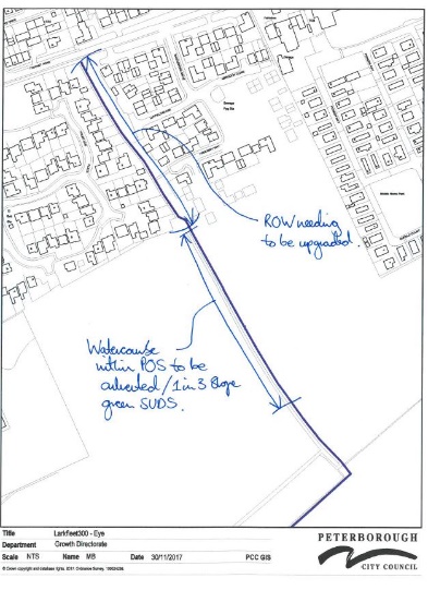
- The Right of Way from Thorney Road leading into the newly proposed Public Open Space to be upgraded to an Adoptable Highway standard footpath along with the installation of street lighting
- It is noted Larkfleet propose onsite provision of 2 x LAP’s. PCC will require onsite provision of a Super Local Equipped Area of Play – SLEAP with inclusion of Toddler Play as below:
- These areas will be aimed at children between the ages of 2 – 10 years and will be located within a 450m straight line distance of every dwelling. There will be a minimum area of 500m2 activity zone, surrounded by an appropriate buffer zone; 20m to the face of the nearest dwelling. Separate grouped provision for young children (up to 6 years) is to be incorporated within the SLEAP. The play area will consist of at least 7 types of play equipment.
- It is noted that on the indicative Layout Plan submitted ponds are to be created, this is unacceptable to PCC. Green SUDS basin’s are to be used with the gradient to not exceed 30. PCC’s Drainage Section can provide a full and detailed specification for this element.
- PCC will require onsite provision of 0.933 ha of Natural Greenspace
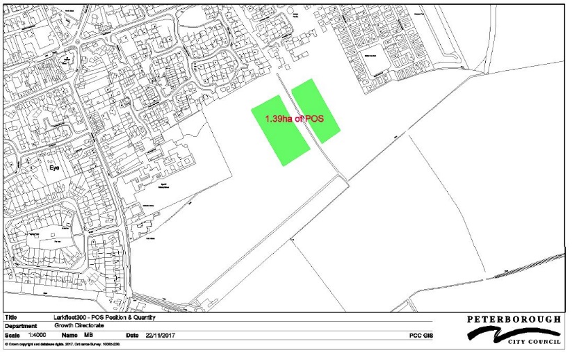
- PCC will require onsite provision of 1.39ha of POS within a central position
19. I object to this application as there is no provision for Indoor Sports and Recreation Facilities
- PCC Policy LP21 – New Open Space, Outdoor Sport and Recreation Facilities. Part B Indoor Sports and Recreation Facilities states
- All residential development below 500 dwellings will contribute to the provision of ‘off site’ strategic indoor sports and recreation facilities by way of CIL. The precise contribution/obligation will be negotiated on a case by case basis.
20. I object to this application as there is no provision for Designated Sites – Mitigation of Recreational Impacts of Development on the sites of special scientific interest (SSSI) designated Eye Green Nature and SSSI designated Dogsthorpe Star Pit Reserve
- PCC Policy LP21 – New Open Space, Outdoor Sport and Recreation Facilities. Part C Designated Sites – Mitigation of Recreational Impacts of Development states
- Where a new development has the potential to have significant adverse effect on the integrity of a designated international or national site for nature conservation purposes, as a result of additional recreational pressure on that designated site, the development may be required to provide open space of sufficient size, type and quality over and above the standard requirements set out in this policy, in order to mitigate that pressure.
- Mitigation may also involve providing or contributing towards a combination of the following measures:
- Access and visitor management measures within the designated site;
- Improvement of existing greenspace and recreational routes;
- Provision of alternative natural greenspace and recreational routes;
- Monitoring the impacts of new development on international designated sites to inform the necessary mitigation requirements and future refinement of any mitigation measures
- There is no mention for the above provision and its impact on
-
- The SSSI designated Eye Green Nature Reserve
- The SSSI designated Dogsthorpe Star Pit Reserve
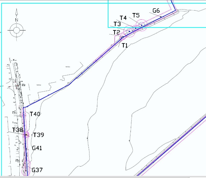
21. I object to the removal of Tree T38 identified in Larkfleet’s Arboricultural Impact Assessment Doc Ref 17-1884 13/12/17 table 3 because it is in the footprint of the proposed site access road. The road access point needs moving further towards mixed group G41
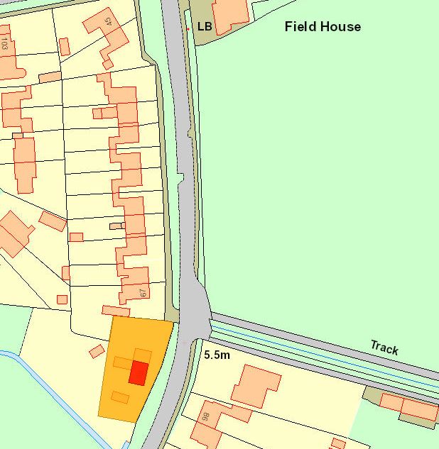
- It is an Ash tree worthy of keeping and identified in Larkfleet’s BS5837 2012 Tree Survey Schedule as located Off site, in a fair condition, early maturity tree with a 330 cm diameter and needing protection during development.
- As its off site it is owned by Peterborough City Council as its on the verge of Eyebury Rd
- It is in the visual line of the houses opposite and has amenity value contrarily to the impact assessment statement in table 3
22. I object to the removal of 20 Mtrs of mixed species G41 identified in Larkfleet’s Arboricultural Impact Assessment Doc Ref 17-1884 13/12/17 table 3 because it is in the footprint of the proposed site access road.
- The loss of 20 Mtrs of mixed species is excessive as it is worthy of keeping and identified in Larkfleet’s BS5837 2012 Tree Survey Schedule as located Off site, in a fair condition, early maturity mixed group and needing protection during development.
- As its off site it is owned by Peterborough City Council as its on the verge of Eyebury Rd
- It is in the visual line of the houses opposite and has amenity value contrarily to the impact assessment statement in table 3
- PCC Conservation Officer is concerned that the hedge row be retained/improved to mitigated the impact on the grade 2 listed building opposite and close to the site as per pasted below
‘Provided that the scale of the buildings fronting Eyebury Road do no exceed 2 storey and the mature hedgerows on the boundary of the site are both retained and added to in weaker areas (Where the existing field entrance is) as part of a landscaping scheme, the impact on the setting and significance of the listed building will be minimal. The denser the landscaping scheme to the front of the site the better.
I question why plot 184 is sited so far forward of the established building line? This reduces the potential for a decent landscaping buffer.’
23. I object to the close proximity of the school entrance to Tree T5 a category B Medium Quality and value Horse Chestnut with 20-40 yrs life ) it needs to be further towards the mixed species group ID G6 to the East
- Identified in Larkfleet’s Arboricultural Impact Assessment Doc Ref 17-1884 13/12/17 The RPA of T5 could be affected by the proposed access road to the school. The current indicative position has the potential to impact 32m2 (equalling 17%) of a radial RPA
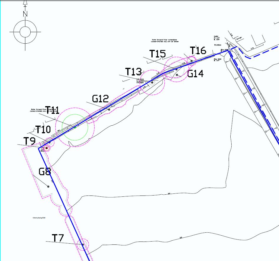
24. I object that Tree T22 Elder has not been included in the list of trees to be removed in Larkfleets Arboricultural Impact Assessment Doc Ref 17-1884 13/12/17 table 3
- It identified as Over Mature with less than 10 years remaining in 2012 and either Dead, dying or dangerous with a recommendation of removal in Larkfleets BS5837 2012 Tree Survey Schedule.
- Plots 232 and 233 are being built close to Tree T22 which has a recommendation of removal as per para a) above.
25. I object that Tree T9 Elm has not been included in the list of trees to be removed in Larkfleets Arboricultural Impact Assessment Doc Ref 17-1884 13/12/17 table 3
- It is identified as Dead with less than 10 years remaining in 2012 with a recommendation of removal in Larkfleets BS5837 2012 Tree Survey Schedule.
- It will also be inside the land allocated to the school so should be removed.
26. I object to not have a Tree Protection Order (TPO) for the Large Oak T11 identified as Category A and having High Quality and value as identified in Larkfleets BS5837 2012 Tree Survey Schedule.
27. I object to the location identification ownership information provided in Larkfleets BS5837 2012 Tree Survey Schedule
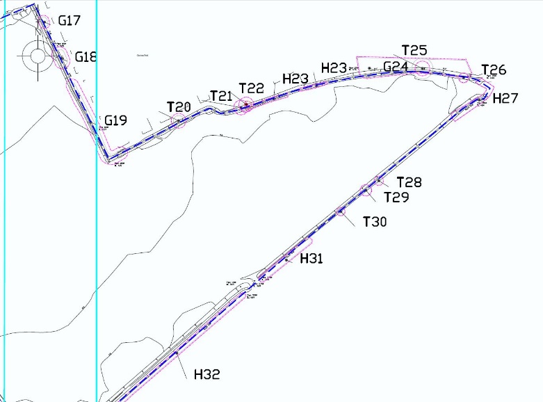
- The survey states ‘Off site trees and hedges, protect during Development’. Certainly Trees T9 to T19 and G12 and G14 are within the boundary of the development site and therefor are the responsibility of the developer to prune, protect and have a maintenance agreement with the council going forward, there should be a full analysis of all trees to see if any more our within the developers boundary to correct this error in the submission
28. I object to this application as there needs to be significant tree/shrub planting within the proposed school extension area especially to the boundaries with the adjacent new housing, and along/adjacent to; the central northern boundary and up the boundary heading NE towards Thorney.

29. I object to this application as there is no Arboricultural Method Statement to provide details of how the necessary tree protection can be implemented, initial pruning and maintenance plan and ownership going forward across the housing site and the land allocated for the School expansion
30. I object to this application as there is no plan to upgrade Eye Sewage System before the site works start along with an onsite pumping station and the Anglian Water S104 and PCC S106 agreement
- Pasted below is the requirement pasted from Larkfleets Flood Risk Assessment dated Oct 2017 Ref No MA10525-FRA-R01:
- 3.2.3 The foul drainage from this development is in the catchment of Peterborough (Flag Fen) Water Recycling Centre, which currently has the capacity to treat the flows from the proposed development site. AW has assessed however that a direct connection to the public foul sewerage system is likely to have a detrimental effect on the existing sewerage network. Therefore, to enable a solution for draining the foul flows from the proposed development, AW has conducted further hydraulic modelling of the foul system, the study of which can be found in Anglian Waters Drainage Impact Assessment Report Ref.19597 dated 7th April 2017, contained within Appendix B.
- 3.2.4 The analysis has been performed on the foul system only and does not take into account any surface water flows. The analysis of foul flows from the development site comprising 350 dwellings has been modelled connecting to manhole reference No. TF23020401 (grid ref: TF23009 02403), located on Eyebury Road.
- 3.2.5 The study concludes that the development will cause detrimental effects to the capacity of the current sewer system and will result in increased flood risk downstream of the proposed connection point.
- 3.2.6 In order to mitigate the impact of the proposed development upon the network, AW has recommended the following:
-
-
- Upsize 112m length of 225mm diameter sewer to 650mm diameter situated on the corner of Eyebury Road and Little Close.
- Upsize 44m length of 300mm diameter sewer to 825mm diameter situated on St Michaels Walk near Eye- Little Close pumping station.
-
31. I object to this development as there is no agreement with North Level drainage Board or plan and S106 agreement before the site works start
- A substantial watercourse known as Tanholt Drain flows North to South through the site, returning partially along the Southern boundary before exiting the site. Tanholt Drain is administered by North Level District IDB.
- The proposals for a road crossing over Tanholt Drain would need Land Drainage Consent from NLIDB
- Pasted below is the requirement pasted from Larkfleets Flood Risk Assessment dated Oct 2017 Ref No MA10525-FRA-R01:
3.2.12 It is anticipated that surface water disposal will be via a gravity fed system into roadside swales and ponds, before discharging with flow control into the Tanholt Drain watercourse located within the site boundary, as indicated on the proposed drainage strategy contained within Appendix A.
d. Pasted below is a copy of North Level Drainage Board Objections

32. I object to this development as there is no detailed plan for Larkfleets Flood Risk Assessment dated Oct 2017 Ref No MA10525-FRA-R01:Section 8.2 Recommended Mitigation Measures needed for the moderate risk of flooding as stated in the para pasted below
a. The assessment of flood risk in Section 7 of this assessment confirms a MODERATE risk of flooding from, adjacent land and sewers. There is a LOW risk of flooding from all other sources.
b. Pasted below is an extract from the PCC Drainage Team Officer dated 6th Sep 19 where it states “I note in Section 7.2 of the Flood Risk Assessment (dated October 2017), it makes reference to surface water flooding. In review of the Environment Agency’s Long Term Flood Risk Map a significant area of surface water flooding is shown within the proposed development area. At the detailed design stage, this area needs to be accounted for and managed, in order to ensure that this surface water is not redirected off site.”
c. As per LP40 the request at item b) above needs to be done at outline planning stage not detailed design stage
33. I object to this application as the Larkfleet flood ponds utilise the Open Space area allocations rendering them un usable during heavy rain events and winter and impacting the wildlife ponds which would become contaminated with road surface water e.g. road salt see diagram pasted below is the requirement pasted from Larkfleets Flood Risk Assessment dated Oct 2017 Ref No MA10525-FRA-R01: Appendix A
34. I object to this development due to the poor flood risk documentation for the drainage of the new parcel of land allocated to the school extension
- Pasted below is an extract from the PCC Drainage Team Officer dated 6th Sep 19 where it states “As per the Flood Risk Assessment, the whole site is designed for up to the 1 in 100 year critical rainfall event including a 40% climate change allowance, This also includes the field that is proposed as part of the school extension. As such, we require clarification of how this field is proposed to drain and how any overland flood flows will be managed and properties protected from this.”
- Pasted below is an extract from Larkfleets supplied Archaelogical Desk based Assessment pg 20 Doc Ref PCAS Job No. 1983 Dated Mar 2018 it shows a flooded ditch on edge of school in Feb 2018
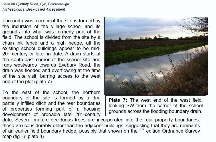
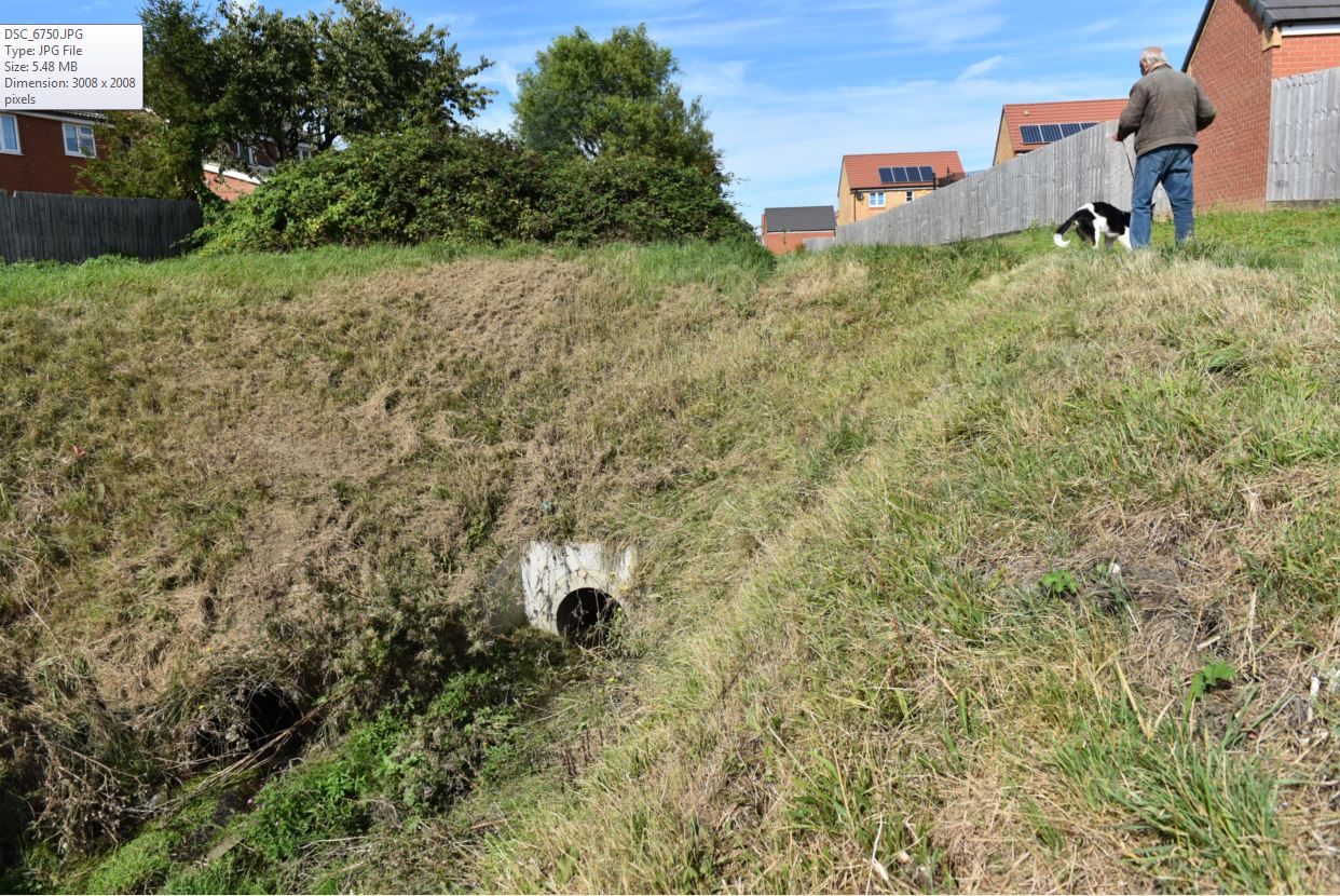
c. Currently the drain adjacent to the school playing fields does not go into the main drain on the site and as such it floods during the winter and the school playing fields are water logged (see plate 7 above of drain in winter) and photos below taken in Sep 19. There is no detail in the plans on how to drain this water and provide drainage to the new vehicle park and playing fields within the school
d. There is no information on how the ditches and drains on the site boundaries will be connected to the drainage system e.g. along the Northern boundary with Thorney Rd, there should be a full analysis of all ditches and drains to see if any more are within the developers boundary to correct this error in the submission.
For Reference: Peterborough Local Plan Adopted 24th Jul 2019 – Policy LP40: Tanholt Farm, Eye
Do they not think they should make the school bigger or build a new one before they even think about building new homes which this village does not need.The police are hard pressed to patrol the village streets now, how will they cope
Do not think these plans should go a head as there not many areas in Peterborough where you have that close village community factor about it also traffic at certain times of the day is horrendous as it is !and fearing as a result what will happen to our village if these plans go head .