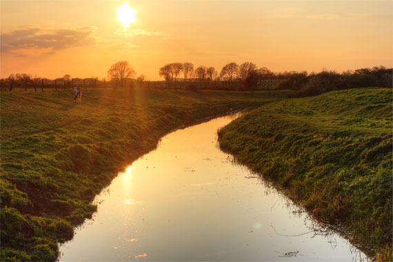
The Car Dyke is an eighty-mile artificial water channel, thought to have been constructed by the Romans from the first century AD, during the reign of Emperor Hadrian. The Dyke runs along the western edge of the fens from the River Cam near Cambridge all the way to the River Witham, just south of Lincoln. Many stretches are protected as a scheduled ancient monument. The section between Eye and Peakirk is maintained by the Environment Agency.
There seems to be a number of reasons as to why the Romans constructed Car Dyke. It may have been a way of providing drainage or a defensible boundary like Hadrian’s Wall, or a canal to transport goods. There seems to be no single account that can explain the full length. Even so, along with Hadrian’s Wall, it was most certainly one of the greatest engineering feats carried out in Britain by the engineers of the Roman Empire, who ruled the country for almost 400 years from 43AD to 410AD.
It was William Stukeley that came up with the idea that Car Dyke was a canal in the 18th century. Born in Holbeach, William Stukeley (7 November 1687 – 3 March 1765) was an English antiquarian who pioneered the archaeological investigation of Stonehenge and Avebury. He surmised that the purpose of the canal was to supply the Roman Armies of the north with grain and food from Lincolnshire and Cambridgeshire with drainage as a secondary function, a view which still perpetuates until today.
In 1958 a large number of Roman tiles were found between Star Pit and the north-east of Clay Lane and in 1963 a Roman coin dating from the time of Nero was found when a new house was being built on Peterborough Road, just a few metres south of the dyke.
After many delays, the section of Car Dyke between the parish boundary and Newark was piped and filled in during the 1960s. Derek Crouch won the contract to do the work.
In 1989 the Trust for Lincolnshire Archaeology investigated of part of the Lincolnshire section of Car Dyke in Baston, just a few miles north of Eye. The excavations showed that the dyke was originally 13 metres wide and 3.6 metres deep and the Dyke originally contained fast flowing water. They came to the conclusion that it was constructed as a catchwater drain but couldn’t rule out it being used as a local means of transportation. In 120AD the Roman Emperor Hadrian visited Britain and the sections dating from this period may be associated with his plan to settle the Fens, which gives weight to the drainage theory.
Excavations at the south end of Car Dyke in Waterbeach near Cambridge in the 1990s found slightly different results and what seemed to be the remains of a Roman-era boat and cargo of pottery. Other archaeological investigations have found coal from the Midlands in use at a cluster of Roman-era coal-burning forges sited between Cambridge and the Wash and these provide evidence of trade and transport along the Car Dyke. At its northern end accounts of Roman Britain describe it as an extension of the Foss Dyke, an accepted transport route. Near Morton, Lincolnshire, a boatload of dressed quarry stone, identified with the medieval period, has been discovered in the canal bed.
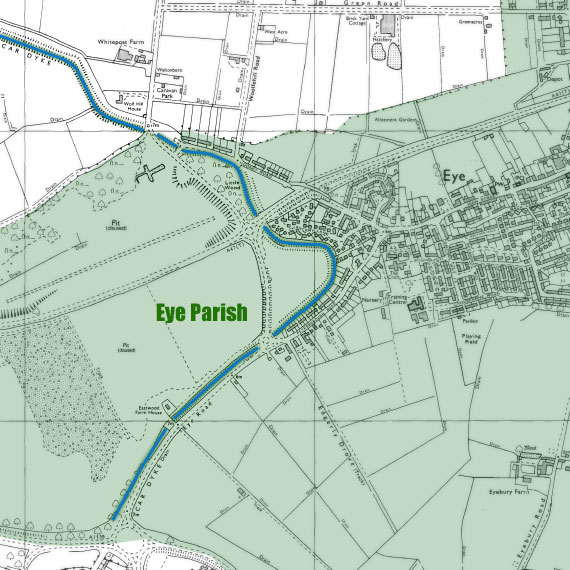
Car dyke enters the Parish in the South West running alongside Eye Road, it then turns nearly 180 degrees at Beech Lane before proceeding northwest along the back of Chancery Land and Hodney Road. The width of the dyke varies from 29 metres at the Whitepost end to 16 metres at the Peterborough end. The sharp bend creates an unusual course for the Dyke but this would most likely have been due to the necessity of keeping the levels – making sure water will flow the correct way. The dyke was re-excavated in 1969 after becoming silted up.
We have no idea what the Romans called the canal but in the 13th century the Dyke was owned by a man called Kari, hence Kari’s Dyke or Car Dyke while in old English “Car” means overgrown (with marsh, reeds and shrubs).
The Roman period ended in Britain in the early 4th century AD. Britain at the time was suffering raids by the Scots, Saxons, and Picts. Commander of Britain at the time Constantine III rallied the remaining troops in Britain, led them across the Channel into Gaul and set himself up as Eastern Roman Emperor. In 410 Honorius, Western Roman Emperor, sent letters to the cities in Britain urging them to fend for themselves.
By the end of the 4th century the Dyke was probably still in workable form but without maintenance, many stretches of the dyke would have started to silt up. Then in post-medieval times ploughing reduced the banks and filled in what was left.
Luckily the Eye section still survives, as a reminder, that during the first or second century AD the Romans were digging a channel to the west of a small island in the Fens, a place that future generations would call the village of Eye.
Reference
Wikipedia
Does anyone know how much of the Car Dyke today is still a waterway, and how much has been filled in and put to other use?
Andy
My latest book
“Exploring the Fen-Edge” along the Roman Car Dyke.
From Peterborough to Lincoln visiting towns churches villages and interesting sites along the way. includes maps and symbols for walks and remains of the Car Dyke.